

|
|
|
|
| writings || books || projects || madvertising || odds & ends || about || bio |
various essays on, well, art and culture lessons learned from this profession
ok, I'm not the guy from SNL,
mostly true stories from my more "it's all about me"
I’m at -7.13/-7.33 on The
Political Compass. Where observations on the human condition
Europe 1994
Wales 2006
|
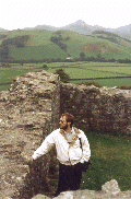
One of the most evocative places in all WalesMonday, 3/20 We had decided the night before that today we would go explore the southern section of Pembrokeshire. After breakfast at the cottage, we gathered up the goodies we thought we would need for the day, and headed out. The weather was mostly sunny, warmish (low 40's - which was relatively warm in comparison to what we had been experiencing). West to Carmarthen, stopped at Morrison's to pick up some items and see what their hours were, and then further west on the A40 to the town of St. Clears. Down the A4066 to the seaside town of Laugharne (which the locals pronounce as "Larn," in that fine British tradition of dropping inconvenient syllables in the middle of names). This small town was the home of Dylan Thomas for the final years of his life. The snarky part of me thought "No wonder he went to New York and drank himself to death." But ignore that - it was a nice little town. We wound our way through Laugharne, eventually finding signage pointing the way to his boathouse. We parked the car, walked down a lovely shaded path looking out over the estuary to the east, pausing to watch workers rebuilding part of the slate wall using the classic 'rubble-fill' technique common to walls and castles alike. Some things never change. First we came to the tiny garage where Thomas did most of his actual writing, which has been set up as though he has just stepped out for a moment (likely to the local pub . . .) Then another 50 yards along to the boathouse itself, which was home for him and his family. It is, in a word, quaint. Picture-postcard quaint. Every-artist-in-100-miles-has-to-paint-it quaint. You get the idea. Located somewhat lower than the path we were on, the converted boathouse overlooks the tidal flats then across to several points of different peninsulas of Carmarthenshire poking into Carmarthen Bay. The house has now been turned into a nice little shrine in Thomas' honor. It is a small home, very much as it likely was in the early 1950's when Thomas and his family lived there. There are two rooms upstairs - one a viewing room for a 70's-era vid about Thomas, the other full of displays of his work published in different languages (including a nice selection of letterpress books!). The floor below contains the office/shop and a formal living room complete with sleeping cat. The floor below that has a tea room and kitchen. All the rooms had a lot of local artwork with a Thomas theme on the walls. Lots of renderings of the boathouse, of course. Some of the art was fairly good. Some, not so much. But I'm an art snob. We went out, back up to the path, pausing to walk about a bit on the grounds of the boathouse, taking in the view of the estuary. Beyond the boathouse workers were busy putting in a new footing for the hillside sea wall. It was fascinating, particularly for Alix, since they were using heavy equipment suitable for working in the small spaces typical of urban European. I seldom think of a backhoe as 'cute,' but the term applied here. Alix took many pictures. After, we walked back to the car, settled on our next destination, and then took off. We stopped in St. Clears for some lunch at a well-appointed pub, not wanting to repeat the previous day's experience of being too busy to eat. Lunch done, we went down the A477 to the A478 to Tenby, looking for one of the holy wells I'd read about to the west of that town. Now, if you happen to find yourself in Tenby, don't panic. Sure, there's this weird double-traffic-circle thing which makes you feel like you're on a Mobius strip, and that spits you out seemingly at random (we had to drive through the minuscule streets of 'old Tenby' - twice - before getting lucky and going in a different direction), and the signs to wherever you want to go seem to be missing when you most need them (and mind, we've traveled extensively in Wales, and know all the tricks to finding hidden traffic signs). But it is pretty little city. I had been intrigued by this entry in the Sacred Springs book: The little hamlet of Gumfreston retains an air of tranquility far removed from the bustling coastal resort of Tenby barely 2km away. From the churchyard gate a path leads down the hillside, past the ruined walls of a priest's house, to the three bubbling wells beside the fourteenth century church of St. Lawrence. Rough stone walling embraces two of the springs, and while the structural remains may be less impressive than at certain other holy wells, the serene and peaceful atmosphere makes Gumfreston one of the most evocative places in all Wales.I mean, how can you not want to see someplace described that way? We (eventually) found the B4318 going west out of Tenby, and took it. Just at the outskirts of Gumfreston, saw a sign for St. Lawrence’s Church. It was on the south side of the road, just a quick left turn (remember, you drive on the left side in the UK). The road drops down sharply, winding through trees and stops in a small parking lot. It was like a glimpse into the 12th century (yeah, I know, the author cited above said 14th - but everything else I've seen about the site says 12th). There's a Norman-style square tower, with an attached low stone church building. Ruins of the very small priory on the right. Through the tumbling stone wall into the yard. Gravesites, even some very recent ones. Everything was lush, green, almost like the American Gulf Coast in high summer, but without the heat. We popped into the church, stepping down several steps, into the long, low building. The roof is supported by ancient wooden trusses; arching, layered, pegged together. The walls are unfinished stone on the outside, but inside there’s a thick layer of render, now painted light peach, with plaques of brass marking this or that period of renovation sponsored by some worthy every 100 or so years. Red & black tile on the floor, in a criss-crossing diamond pattern, borders defining the aisle between the rows of short pews. Add incense, replace the few electric lamps with guttering candles, and it'd be easy to believe you had missed eight or nine centuries of so-called progress. Back outside. Turn left, continue down the hill. When you get clear of the side of the church, you can see the wells in their own little secluded niche. Three different wells, all clustered together, purportedly from three distinct sources, and each supposed to have slightly different curative powers. All three have the slight burbling of natural gas rising up through them. All around the wells are snowdrops, daffodils, and some small red ground plant I couldn't identify. Further out, providing protection from the outside world, are thick curtains of vines, just starting to emerge from winter dormancy, draping down from massive ancient trees. Evocative, indeed. Here's a link. I took a sample of water - drawing some from each of the three wells into my bottle. There was something shaping this place, some energy I could sense. Not the same intensity as at St. Cybi's. Certainly not like poor, forgotten St. Cenydd. This was an old place, one still venerated. Small ribbons and bells are the latest marks of pilgrimage, tied to trees and bushes near the wells. We lingered, just soaking it in. And when it was time to go, after a while, I knew this would always be a place to stay with me. We made the short hop back to Tenby. Well, almost. We hooked up with the A4139 just outside of the town, then skipped down the coast first south, then west, to the town of Manorbier. Alix had noted a castle there, in private hands. It was, you guessed it, closed for the season, but the views of the town and seacoast were delightful. Next, it was west to Pembroke, taking the A4139 the whole way. We parked below the old city, walked up. Pembroke Castle is on the uppermost point. The castle is in a private trust, but it has been well cared for and they've done a lot of good work with the restoration. It is just huge. Here's the page from the Castles of Wales website, with great images and descriptions. I think of all the things we did this trip, this was where we screwed up the biggest - Pembroke Castle needs a lot more time than we gave it, in order to appreciate it fully. We did spend long enough to quickly go through most of it, and even made it down to the storybook cave below, but we didn't do it justice. My advice would be to see this Norman beauty if you can, but give yourself the better part of a full day to do it right. We moved on. Alix knew of a picturesque chapel on the southernmost point of the peninsula which had a long history, was a site of pilgrimages, was mentioned in my holy wells book, and showed up in a mystery book she had read (Named of the Dragon by Susanna Kearsley). So we took the B4319 south until we turned off onto local roads, and then drove through a military bombing range (my book indicated that you should call ahead, to see if the road is open. We didn't.), to one of the most well known holy sites in Wales: St. Govan's Chapel. There's a reason it is so well known: you couldn't ask for a more stunning location. The medieval stone chapel is wedged into the cliffs overlooking the sea, almost down at the waterline. The area around it, when not being pummeled by artillery shells, is a game preserve. It's got that whole 'beautiful bleak coastline' thing going for it. Which was evidently part of the appeal for the chapel, built during the popularity of remote hermitages in the 14th century, though the legend of St. Govan dates back to the 6th century (like all good Celtic saint's legends do). Anyway, we rolled into the parking lot, and saw evidence immediately of the popularity of the site: designated parking for tour buses. Fortunately there were none of those there when we pulled in - one of the advantages of being very much in the off-season. The path from the lot to the chapel is well marked, and the steps leading down the cliff face show further evidence of heavy traffic, as they have been recently refurbished, with a hand rail, and even had 'no-skid' tape in some spots. We went down the stairs. The chapel is in just a crack in the cliff, spanning from one sheer rock face to the other. You come down the crack and enter the chapel on the side. There isn't much to see inside, just the worn and scratched walls. The well, which once filled a small stone basin just inside the door, is now dry. You can exit out an adjacent wall, and will find yourself scant yards from the sea, complete with sea spray, fussing gulls, et cetera. The roar of the surf is quite wonderful. Well, the whole site is quite wonderful. We climbed back out, took some photos, walked a bit looking at the birds. Then back into the car, out of the bombing range, and back on the B4319. But we didn't head back to Pembroke just yet. Instead, we went west, through the stunning dunes of "Freshwater West" (no idea why it is called that. I can't seem to find a "Freshwater East" or anything, and while it is indeed on the west, the water is seawater. Go figure.) This wonderful beachfront is also one of the most popular surfing locations in the UK. But what I loved was that the road is almost overwhelmed by the dunes, which tower over the road in places, and which, of course, move over time and probably present a major headache for the road maintenance folks. Why build a road through there? Umm, no idea. Anyway, our destination was the small seaside town of Angle, which lies on the most northwestern spit of land of the southern Pembroke peninsula. Oh, go look at a map. The town is evidently also featured prominently in the Kearsley novel I mentioned earlier. There isn't much to it, which probably keeps things simple for the author. Maybe she'll graduate to writing about a full-sized town someday, with aspirations of moving on to a small city . . . Regardless, it was a nice, narrow little town. About every second vehicle seemed to be some version of a Landrover. But they were all honest working vehicles, not trophies, as so many SUVs are here in the States. Kinda weird. We went up the main strip, turned around, and came back down it, Alix trying to place locations in the book. But night was falling, and we decided not to stop, but to head back home. We took the B4320 to Pembroke, then the A477 to St. Clears, then the A40 back to Carmarthen. We stopped again at the Morrison's, got some groceries, and did the 15 mile run back to our cottage. Since nightfall comes early (did you know that the UK is actually at a considerably higher latitude than the US? No, seriously - it's way up there with northern Canada. And so, winter/summer variation for the length of day is a lot greater than it is here in the States.), it wasn’t that late when we did finally make it back to the cottage, but still it was a matter of making a quick dinner, writing some postcards, making notes of the day's journey, and then crashing.
|
|
contact me: jim@afineline.org |
all work © James T. Downey, 1993-2006 photos © Martha K. John, 1994-2006 |
site designed and maintained by: Coeurbois Graphic Design |